TYSONS U.S.A. BUILDINGS, DEVELOPMENTS, & MORE
TYSONS, VIRGINIA U.S.A.:
ALL THINGS BUILDING, CONSTRUCTION, & MORE
| Tysons Eight Districts (This page features information about Tysons Eight Districts as defined & voted by Fairfax County) NOTE: The Districs as shown here are in no particular order as defined, agreed, and voted by Fairfax County |
NOTE: This is a clickable image map where you can individually select a Tysons District to get more info in a new window.
DESCRIPTION OF TYSONS EIGHT DISTRICTS (BY FAIRFAX COUNTY)
Every metropolitan city has one downtown, but each downtown is made up of many places: each is a part of the larger whole, but also a unique place with its own distinct personality. Tysons will be no different. The new Tysons will function as a downtown. It is also envisioned to be divided into eight places, or districts, that serve different functions: places to work, to live, to shop and to play. The land use concept for Tysons was created consistent with this concept: an overall vision for Tysons, with individual, unique visions for each district that fit within the larger vision for Tysons as a whole. Tysons’ eight districts fall into two categories: • Transit-oriented developments (TODs) – the four station areas of Tysons West, Tysons Central 7, Tysons Central 123 and Tysons East; and • Non-TOD areas – the districts of North West, Old Courthouse South, East Side and North Central that abut the communities surrounding Tysons. All of the districts within Tysons are equally important to its success. The land use characteristics of each district may be different, and the TODs around the transit stations may be bigger than the districts on the edge of Tysons, but one is not more important than the other. Just like the rooms in a house, each of the TODs and the edge areas will serve specific functions. People who live and work in Tysons may use all of these places, but not at the same time. Just like a house, each district will be connected to the others and the boundaries between the districts will be blurred as people move seamlessly from one place to the next. The connectedness and uniqueness of each place will feed off each other to create an 18-hour place of great vitality. The map on the following page shows the location of the eight districts. This is followed by descriptions of each district and discussion of how they connect to the other districts in Tysons.
Every metropolitan city has one downtown, but each downtown is made up of many places: each is a part of the larger whole, but also a unique place with its own distinct personality. Tysons will be no different. The new Tysons will function as a downtown. It is also envisioned to be divided into eight places, or districts, that serve different functions: places to work, to live, to shop and to play. The land use concept for Tysons was created consistent with this concept: an overall vision for Tysons, with individual, unique visions for each district that fit within the larger vision for Tysons as a whole. Tysons’ eight districts fall into two categories: • Transit-oriented developments (TODs) – the four station areas of Tysons West, Tysons Central 7, Tysons Central 123 and Tysons East; and • Non-TOD areas – the districts of North West, Old Courthouse South, East Side and North Central that abut the communities surrounding Tysons. All of the districts within Tysons are equally important to its success. The land use characteristics of each district may be different, and the TODs around the transit stations may be bigger than the districts on the edge of Tysons, but one is not more important than the other. Just like the rooms in a house, each of the TODs and the edge areas will serve specific functions. People who live and work in Tysons may use all of these places, but not at the same time. Just like a house, each district will be connected to the others and the boundaries between the districts will be blurred as people move seamlessly from one place to the next. The connectedness and uniqueness of each place will feed off each other to create an 18-hour place of great vitality. The map on the following page shows the location of the eight districts. This is followed by descriptions of each district and discussion of how they connect to the other districts in Tysons.
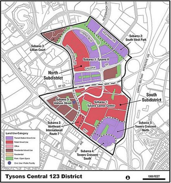
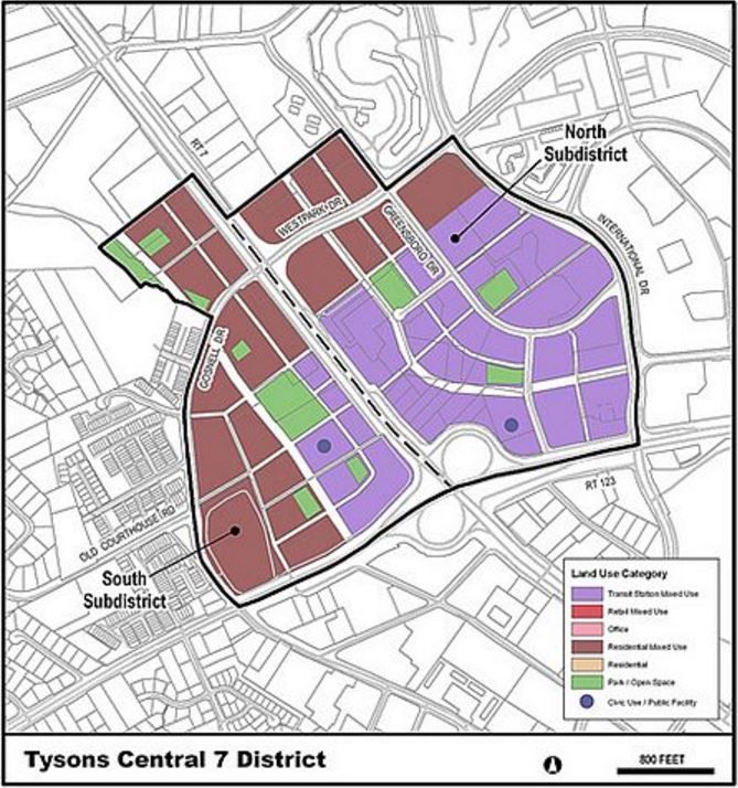
| TYSONS CENTRAL 123 | TYSONS CENTRAL 7 |
|---|---|
| Tysons Central 123 could remain the region’s signature shopping destination by building upon the strength of the existing regional retail offerings and bringing streetfront, ground floor retail and entertainment to the Metro station area. Parking could be shared by numerous businesses in centrally located parking structures with some short-term parking provided onstreet. One unique element in Tysons Central 123 could be a parking structure built into the side of the hill between Tysons Boulevard and West Park Drive. Rather than disrupt the district’s character or act as a barrier to connectivity, this topographical change in grade may be seen as an opportunity and could be incorporated into the overalldevelopment pattern. As part of this retail district, mixed-use high-rise hotel and conference facilities could offer space for exhibitions and conferences, with immediate walking access to regional retail and quick links to the office concentration in the Tysons Central 7 district. High-end luxury condominiums could be combined with these facilities and benefit from available hotel services. District Key Characteristics • Tysons Central 123 would remain the regional shopping destination for Northern Virginia. • A striking contrast with existing conditions would be the district’s more pedestrian friendly, walkable street network, lined with active storefronts and interesting streetscapes. • Hotel and conference facilities could complement the retail node at the station and benefit from proximity to the concentration of office uses in Tysons Central 7. • Marked connectivity and safety improvements would facilitate walkability around the station and to and from the malls and nearby businesses. • The Tysons Central 123 district would be employment-rich, with approximately two-thirds of the land being designated as employment, and over half of all of Tyson’s retail floor area located in the Tysons Central 123 station area. | The Tysons Central 7 district consists of two subdistricts divided by Route 7: a vibrant 18-hour business center with a high concentration of office space; and a Civic Center full of activity. Along Route 7, a transformed streetscape creates a wide landscaped boulevard lined with high-rise office buildings. This redesign results in a calming of traffic through this office building area while maintaining the capacity of Route 7. The high concentration of office space in the Tysons Central 7 district is intended to provide a buzz of business activity and could be the desired address for businesses who seek signature headquarter buildings for a strong corporate profile. The signature piece of the Civic Center subdistrict that could draw people to the heart of Tysons may be a great public square that would serve as the primary civic gathering place for Tysons. The public square would create a new identity and setting for community events and celebrations in Tysons. New public buildings of significant architectural design – government services, public library, post office, and/or cultural facility – could bring a civic presence, frame terminal views and shape positive urban spaces brought to life by the overflow of a bustling public market, bookshops, restaurants and programmed outdoor events and street life. Extending west to the Northwest district, urban residential neighborhoods could be distinguished by calm, dignified square blocks linked together by tree-lined avenues with cycling, promenade and sitting spaces. Residential blocks with walk-up residential units may provide underground parking and clear gradations of public, semi-public and private space. District Key Characteristics • The amount of land uses designated for office use in the business center subdistrict creates the greatest office concentration in Tysons. • The Civic Center subdistrict could provide a central location in Tysons for government services, such as a library or post office. • A 3.5 acre park located in this district serves as a great public square and gathering place for Tysons. With easy access to transit, the square may be the primary location within Tysons for staging public events such as outdoor concerts or public markets. • In addition to potentially serving as the business core of Tysons, this district also includes much residential development, especially west of the station. • The streets leading to and from Tysons Central 7 should be pedestrian streets, encouraging people to walk and leading people to the Civic Center and the business center areas of the district. |
 |
 |
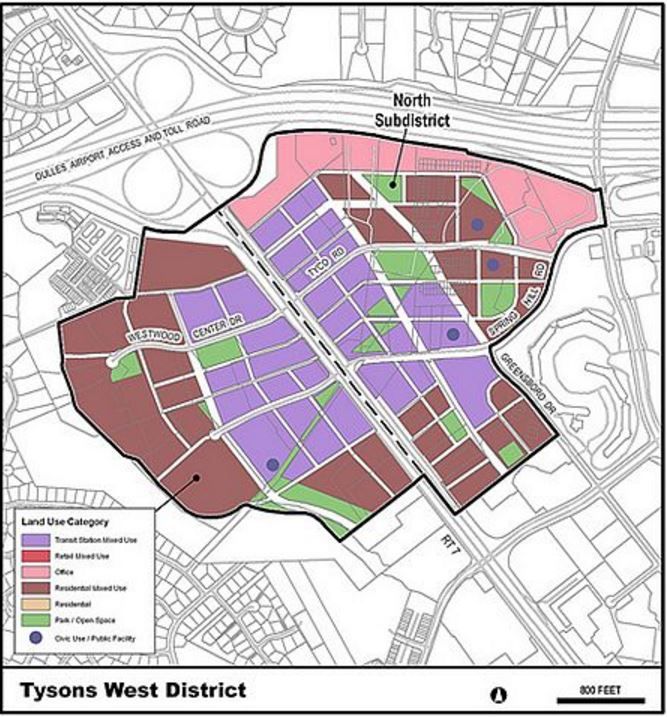
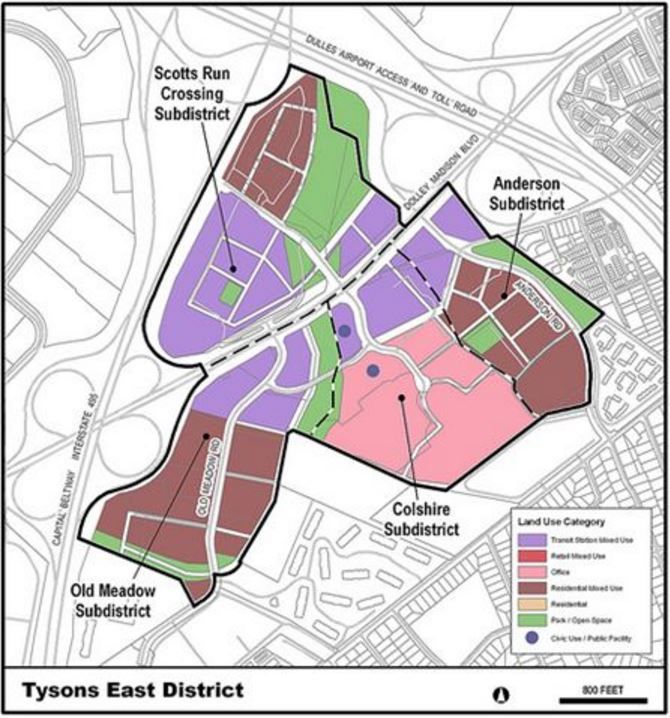
| TYSONS WEST | TYSONS EAST |
| Tysons West is a gateway to Tysons and may be an optimum location for an arts and entertainment district. Following that theme, Tysons West could be a vibrant urban destination. Redevelopment, including a mix of office, residential, hotel and retail uses, provides an opportunity to create an arts and entertainment district that focuses on popular attractions often found in more established downtowns. On the south side of Route 7, ground floor retail uses could include restaurants, private galleries, small theatres, specialty retail and cafés/clubs/bars that would form the basis of an arts and entertainment center. Live/work and loft housing could add the residential element to the center. Together, these ingredients could give this part of the station area a trendy nightlife-rich identity. North of Route 7, a specialty retail street, located east of the station, would bring together office uses and an urban residential neighborhood. Residential units would have inviting street level facades and architectural details along mature, tree-lined streets. A series of urban park spaces would provide attractive neighborhood gathering and strolling places for people of all ages. Moving out from the station, lower intensity development in Tysons West would provide a transition to the surrounding areas, such as the Old Courthouse Spring Branch stream valley park in the North West district and the residential and hotel uses on the north side of Route 7, adjacent to the North Central district. Adjacent to the Dulles Toll Road, office uses are located to provide easy access from the Toll Road and to continue the office focus east in the North Central district. On the south end of the district, more office buildings will create a strong business environment. People would move easily back and forth between the Tysons Central 7 and Tysons West districts to access both transit stations and the supporting services located at the ground floor of the office buildings. District Key Characteristics • Overall, there would be a strong employment focus in the district, with more land uses designated for employment uses and twice as many employees as residents likely in the district. • To complement the other districts in Tysons, Tysons West could be a prime example of an 18-hour place as a key entertainment destination with restaurants and entertainment options open after the workday ends. • Tysons West would be a signature gateway for all of Tysons. Streets leading to and from the transit station would be specialty retail streets, drawing people off Metrorail and into the neighborhoods to shop, play and live. • A series of small urban parks would extend north of Route 7 from the transit station to the residential neighborhoods on the edge of the district. • Route 7 would become a green boulevard with street trees, slowed traffic and a more pedestrian friendly environment. | The focus of Tysons East could be a great urban park surrounded by mixed-use office, residential and educational facilities. Tysons East could include three subdistricts: an office district, a residential district and a focused educational district. The office subdistrict could be immediate to the station. The residential subdistrict could extend to the northeast and to the south-southeast of the station. Educational facilities essential to attracting creative class families could be located along Scotts Run, as could professional education, recreational health and sports amenities. Scotts Run could serve as the central feature of the district as an urban park with a variety of landscapes including wooded hills, meadows and ponds that could provide options for people using the park, such as relaxing and enjoying the scenery, listening to summer music in the park or participating in active recreation. Intimate gardens with shady places of retreat could provide relief and gathering places for families and office workers. Tysons East includes pockets of extensive residential development: urban residential neighborhoods that feature lively neighborhood shopping streets with local-serving goods and services - groceries, bookstores, music stores, video stores, ethnic eating and drinking places. The neighborhoods supply a diversity of housing choices including affordable and family housing on safe, narrow, tree-lined streets with views terminating in open spaces and parks. The Commons apartments are linked to the station by the enhanced street network. District Key Characteristics • Subdistricts include an office subdistrict immediately around the station, and a residential subdistrict extending east and south of the station, beyond the office uses immediately surrounding the station. • The overall focus of Tysons East would be employment, primarily office uses, education and research development. • Pockets of extensive residential land uses create a greater mix of uses in this district. • Scotts Run would be improved to serve as a great urban park, with trails and passive areas, as well as a concert lawn. |
 |
 |
| WEST SIDE | EAST SIDE |
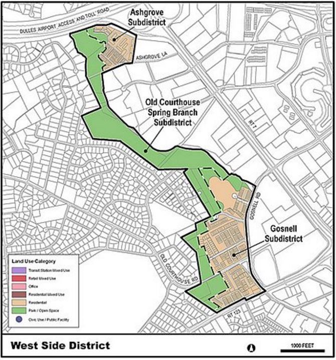
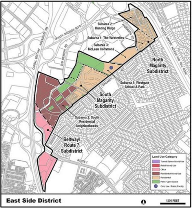
| The West Side district could be a residential neighborhood showcasing the Old Courthouse Spring Branch stream valley park as a key feature. Located on the edge of Tysons West and Tysons Central 7, the West Side district could serve a transition from the higher density mixed-use of the nearby TOD districts to lower density land uses in the neighborhoods just outside of Tysons. The residential character of the West Side district could be similar to the existing conditions with multi-family housing, including housing for seniors. The Old Courthouse Spring Branch stream valley park could be more of an urban park with active recreational facilities and pedestrian pleasures. Tree-lined streets leading to the park could serve a diverse social and economic mix of housing, including housing for families. District Key Characteristics • More than half of the land in this district is park land, consistent with the existing land use. Old Courthouse Spring Branch stream valley park would be enhanced with trails and other passive recreation uses. • The housing in the West Side district would primarily be multi-family, with some housing catering to Tysons’ senior population. • The West Side district provides a buffer between the lower density neighborhoods adjacent to Tysons and the higher density of the TOD areas within Tysons. • Green street connections tie the Tysons West station to the West Side district, drawing people to Old Courthouse Spring Branch stream valley park, the largest natural feature in Tysons. | The East Side district could be primarily a residential district located on the edge of Tysons, to the east and south of the Tysons East station district. As an “edge district,” it could serve as a transition area between the higher density stations in the core of Tysons and the adjacent neighborhoods outside Tysons. The East Side could be a large residential neighborhood, with corner grocery stores to which children could ride their bikes after school or where adults could stop to get a gallon of milk on their way home from work. This district may include only limited retail and office uses, primarily to support the local residential population or to provide Tysons with some live-work opportunities. The tree-lined residential streets through the East Side neighborhoods could serve a diverse social and economic mix of housing. The street network could be a finely scaled grid of streets, encouraging walking and biking. The district could be a peaceful, friendly community where neighbors gather on the street or in one of the many pocket parks to socialize. East District Key Characteristics • With the vast majority of its development residential, the East Side would be first and foremost a neighborhood for Tysons. • Pocket parks located throughout the district support the residential focus. • As an edge to Tysons, East Side would have lower densities than most other parts of Tysons. • Connections to stations would be provided by the streetcar circulator, walking paths and finer grid of streets. |
 |
 |
| OLD COURTHOUSE | NORTH CENTRAL |
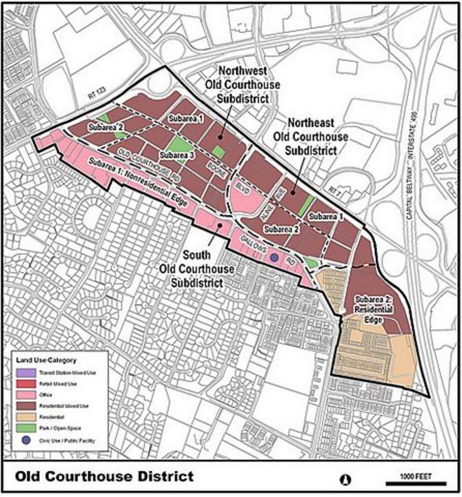
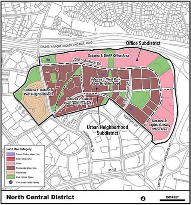
| Located on the edge of Tysons, nestled primarily between Route 7 and Old Courthouse Road, the Old Courthouse South district could have smaller scale office buildings and residential developments than the TOD districts and could serve as a transition area between Tysons Central 123 and the neighboring communities. Old Courthouse South could be envisioned as a neighborhood village with more activity 18 hours a day. When the work day ends, office workers may go home but the residents of Old Courthouse could return to supporting local restaurants and other neighborhood service businesses. Residential development could dominate the heart of the district and the sense of community would be strong as people run into their neighbors at local places such as the corner grocery store. District Key Characteristics • With a mix of retail, office and residential land uses, Old Courthouse South would evolve into a neighborhood that supports an active 18-hour village where people go to restaurants or shopping after work. • The number of residents and employees in the Old Courthouse South district is anticipated to be about equal. • Urban parks may be limited, but a few additional pocket parks could provide gathering places within the mixed-use area. | Located primarily between West Park Drive and the Dulles Access Road, the land use pattern in the North Central district allows for a transition between Tysons Central 123 and the adjacent community north of Tysons (with the Dulles Access Road as an additional buffering element). Office uses are located adjacent to the Dulles Access Road, providing easy access from the Toll Road and continuing the office focus east in the Tysons West district. Moving into the heart of the district, residential land uses are the focus around the streetcar circulator. The district becomes more of a vibrant, mixed-use residential neighborhood, with local-serving retail, dedicated parks and civic uses, and a pedestrian friendly street network for residents and workers in the neighborhood. New pedestrian friendly main streets with ground floor retail could enhance the connectivity in the North Central district. The main streets, along with a finer grid of streets and a linear park green network, could lead people to the streetcar circulator and encourage them to walk. As the central feature of the district, the streetcar circulator could provide form to the district. North Central’s development as a mixed-use district may create an 18-hour day environment. Residential development could be located throughout the district and the sense of community may be strong as people run into their neighbors at the corner grocery store. Several parks in North Central could provide gathering places for the residents, and link Tysons Central 123 and the office employment in the North Central district. District Key Characteristics • North Central would be a neighborhood village with more residential uses focused around the streetcar circulator. • Office uses adjacent to the Dulles Toll Road provide a buffer between the Toll Road and the neighborhood village. • The land uses support an active 18-hour neighborhood where people can go to restaurants or shopping after work, and the increased intensity of uses along the streetcar circulator could give more people direct access to the circulator. • Urban parks may include a green network leading from Tysons Central 123 to the employment area adjacent to the Dulles Access Road and a new 8 to 10 acre urban park along the circulator could be a central feature of the northern portion of Tysons. |
 |
 |
www.tysonscity.net / www.tysonsbuildings.com / www.tysonshighrises.com / www.tysonsinfo.com
Tysons Buildings & Developments Info 2015-2019. All Rights Reserved.
Chantilly, Virginia U.S.A.